Table of Contents
First Steps
This step-by-step tutorial is designed to guide you through the installation of IvAc 2 and the development environment, as well as preparing the first elements of your FIR. It may not cover the same detail as specific element pages located further down in the index.
The Basics
Understand Subversion
All IvAc 2 work is based on Subversion (SVN). A tutorial can be found here.
Understand XML
Most data files are written in XML (eXtensible Markup Language).
Its structure is very similar to HTML (HyperText Markup Language), but it's not restricted to the default structures of that language.
You can learn more about it by following the course on W3Schools and using this Cheat Sheet.
Understand Geographic Coordinates
In IvAc 2, all geographic coordinates are structured like this:


The Hemisphere where the point is located, either N (North) or S (South) for
latitudes and E (East) or W (West) for longitudes.
Degrees, 3 digits, always with a leading zero if less than 100
Minutes, 2 digits
Seconds, 5 digits, including three decimal numbers
So, a coordinate like 42°30'21.154“N would become N0423021154. Trailing zeroes may be omitted: N0402000000 = N0402
Coordinate Overflow
During maps or points development, pay be careful to avoid an overflow error, which was ignored in IvAc 1. The error occurs when you use coordinates with values out of limit, such as:
| Min | Property | Max |
|---|---|---|
| 000 | Degrees (Lat) | 089 |
| 000 | Degrees (Lon) | 179 |
| 00 | Minutes | 59 |
| 00000 | Seconds | 59999 |
The second part of the coordinate cannot be 00001, as it also generates a calculation error. You can safely change it to 00000 to correct the error.
Check the log file (log/ivac.log) for overflow errors, they will look similar to:
ERROR Java2D Queue Flusher : our of range:E0023260000
Initial Setup
Each FIR Definition (or FIRDEF) will be located inside the fir/ directory which is located in your local application data directory:
- Windows & Linux:
%APPDATA%\IVAO\IvAc\ - Mac OS:
Users/(name)/Library/Application Support/IVAO/IvAc/
Note that the fir/ directory is live and will be updated by the launcher. We therefore recommend that you create a separate directory called fir-dev inside which you will checkout the FIR directory from the SVN. If the FIR directory doesn't exist on SVN you can create it yourself or contact a member of Terminal2 Solutions.
You now have to tell IvAc where your development directory is. Open the ivac.conf file, find the fir.dataprep= entry (or add it if it doesn't already exist) and paste the path to your development directory.
On Mac OS it will look like this:
fir.dataprep=/Users/(name)/Library/Application Support/IVAO/IvAc/fir-dev/
On Windows & Linux it will look like this:
fir.dataprep=C:\Users\<username>\AppData\Roaming\IVAO\IvAc\fir-dev\
You can also create this directory anywhere else on your computer.
In our example, we'll use Kathmandu FIR (VNSM) as our working area. So, to begin our work, we create a directory inside the fir-dev directory called vnsm and checkout the corresponding directory from the SVN.
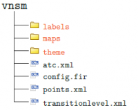
Inside vnsm you will need to have the following files:

You must have these files and
folders in order to see the FIR
in the Launcher Window of IvAc 2. Details
of labels, maps and theme folders
are listed further down in the SDK
FIR structure
Once you have your SVN and development directory operational you should start creating the basic skeleton files for your FIR:
This file contains the basic information for the FIR including name, centrepoint, release date, and default themes.
This file can be used to list all the significant points in your FIR to make map drawing easier.
We suggest you list all frequently used waypoints in this file rather than utilising their lat/lon coordinates when drawing maps.
Maps
Finally, it's time to create maps. We have a dedicated page introducing maps here, please read it carefully.
The file may be daunting at first, but by looking through existing FIR definitions such as Brussels (EBBU), Copenhagen (EKDK) or Switzerland (LSAS) the information should begin to make sense.
Remember you are only drawing what you need to see - so you don't need to list every waypoint or every airway in a 1000 mile radius of you FIR, you just need the information controllers need to do their job. Real radar screenshots provide the best inspiration - use them!
Operational & ATC Data
FIR Definitions rely heavily on accurate operational data. Basic AIRAC data is fetched from the server but we still rely on you to define the rules governing LOAs, Gates, SIDs, STARs, etc… This is information which is not stored in AIRAC cycles.
You also need to define the ATC positions and sectors.
UI Customisation & Presets
Note: Development is still ongoing
You can also edit the look and layout of your aircraft labels, flight lists and the user interface. As we are still actively working on the code base here we suggest you concentrate on other elements of the FIR definition.
If you're feeling adventurous some documentation is already available to read on the SDK, and further experimentation can be achieved by editing the ivac.config and uistyle/default.css files.
If you have any further questions please post them in the IvAc 2 support forum